
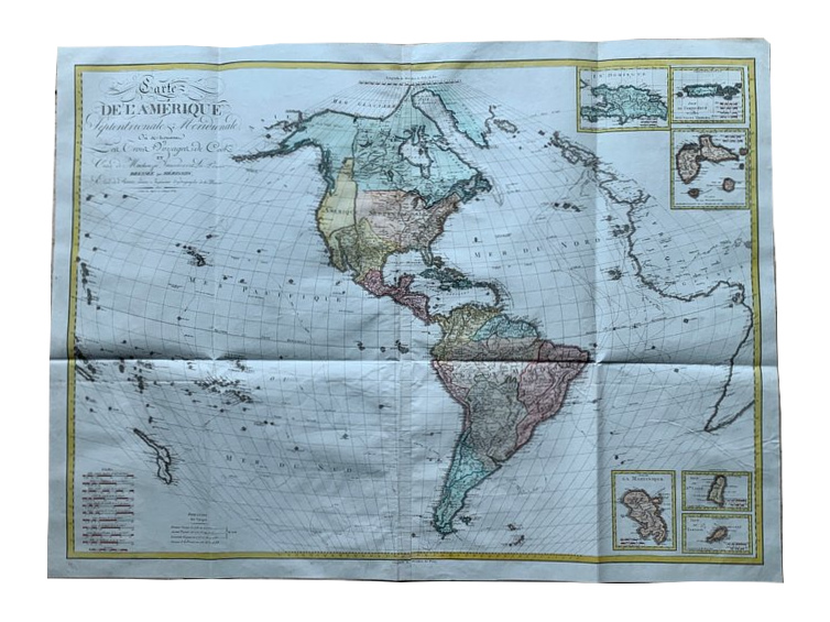
Wall Map of North America and South America, 1810 - Eustache Hérisson
€600
- Cartographer
- Eustache Hérisson
- Date
- 1810
- Publication
- Paris, Basset
- Original title
- Carte de l’Amérique septentrionale et méridionale…
- Subject
- North and South America
- Medium
- Copper engraving with contemporary hand colouring, printed on two joined sheets
- Engraving dimensions (cm)
- 85 × 117
- Paper dimensions (cm)
- 91 × 123
- Condition
- Very good, with visible folds and a central join
About this piece
A large copper-engraved wall map of North and South America by Eustache Hérisson, published by Basset in Paris in 1810. Printed on two joined sheets, the map retains its contemporary hand colouring. Its generous scale allows the Americas to occupy the centre while leaving room for the oceans, New Zealand at lower left, and the coasts of Europe and Africa at the right.
The calligraphic title names James Cook’s three voyages alongside those of Mackenzie, Vancouver and La Pérouse. Those names draw attention to the different kinds of travel the map brings together, from ocean voyages to exploration within North America. The Caribbean insets are worth a closer look after taking in the broad sweep of the main image.
The wall format leaves the insets and the main map room to work at different scales. The broad image gathers the continents and oceans into one field, while the smaller details give parts of the Caribbean space of their own. The join between the two printed sheets remains visible on the full map.
The engraving measures 85 × 117 cm and the full sheet measures 91 × 123 cm. The paper is in very good condition, with visible folds and the central join.